Alaska 2001
This is the log and photo gallery for a road trip from Williamstown,
Massachusetts, to Alaska, and back. Pictures were taken primarily
with my Olympus Camedia C2100-UZ digital camera. Others were taken
with Rob Foulis' Olympus Camedia C2040-Zoom digital camera. All photos
are copyright James D. Teresco or Robert F. Foulis, and may not be
used for any purpose without permission.
As usual, there is more detail here than anyone really wants to read,
but it is all included for my own benefit. You probably don't care
where we had lunch in Fargo. There is even more detail than usual
since the travel logs were entered daily and most pictures were
captioned within a day or two after taking them. Enjoy, but watch out
for pictures of highway signs. Don't say I didn't warn you.
The Plan
The inspiration for the trip came late in 2000, when looking at a web
page of pictures of highway signs. One of them was a sign from the
Dalton Highway, north of Fairbanks which includes "Arctic Circle 1".
I decided I need to go there and started throwing out the idea to many
potential travellers. Many were interested, but in the end, few could
afford the time. Possibilities included driving all the way, flying
both ways, or combining driving with a ferry ride on the Alaska Marine
Highway System. The plan that came together was for Rob Foulis and I
to drive to Whitehorse, Yukon Territory, where we would meet Andrew
Shapira who would fly in from Seattle. The three of us would spend a
week driving around Alaska before we would drop Andrew off at the
airport in Whitehorse, after which Rob and I would continue on to
Skagway to catch the ferry to Bellingham. And from there, we would
head back east mostly on I-90. Slowly, the trip took shape with more
and more plans becoming firm, with (of course) a few baseball games
squeezed in where possible. We didn't get to the "Arctic Circle 1"
sign, but you will see, we saw plenty.
The Pictures
My pictures are linked from the text below. These links also have
many of Rob's pictures. In addition, there are pages of more of Rob's pictures. I have
put a "*" with the links to those pages containing the pictures I like
best, though interesting stuff is scattered throughout. People didn't
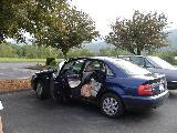
get into many pictures, but my car got into about 30. These are
gathered into one page.
The Trip
Day 1: June 6, 2001 |
 |
 |
We finished packing early in the morning in Williamstown [2 Pictures*], and we were on the road a bit
after 7 AM. In just a few minutes, we crossed our first state border,
entering Vermont on US 7 [Picture]. After
a fillup in Pownal [Picture], we
continued on, entering state three, New York, on Rte 346. We needed
to make a quick stop at Rob's apartment in Troy [Picture], then we were really on our way [3 Pictures]. Our route took us down I-88 [3 Pictures] to Binghamton [2
Pictures], then across the Southern Tier Expressway (NY 17/I-86)
[7 Pictures]. Lunch was at a pizza place in
Hornell [Picture]. [4 more STE Pictures]. We entered Pennsylvania
[Picture] (for the second time, actually, as
NY 17 crosses into Pennsylvania for less than a mile between
Binghamton and Elmira) on I-86. There, we rejoined I-90 for the rest
of the day [4 Pictures]. We entered Ohio
[2 Pictures] and hit some traffic before [Picture] and in Cleveland [12 Pictures], but that was the only
significant delay of the day. We learned that McDonald's sells
bratwurst in Ohio [Picture] just after
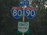
entering the Ohio Turnpike [6 Pictures].
The only other excitement came just after we entered Indiana [Picture], when we got a flat tire and had to
change it on the side of the Indiana East-West Toll Road (I-80/90).
This cost us about a half hour, but wasn't that big a deal. We made a
gas stop soon after by crossing over into Sturgis, Michigan [5 Pictures], giving us seven states on day
1. [3 Pictures from the Indiana Toll
Road]. We arrived at the Super 8 in South Bend [2 Pictures] at around 8:30 EST (this part
of Indiana doesn't do daylight savings).
Day 1 Travel Log
Day 2: June 7, 2001 |
 |
 |
We started in South Bend, Indiana [Picture], and took a short tour of town,
including a quick look at the Notre Dame campus [4 Pictures]. [12
Pictures from the ride from South Bend to Chicago]. We arrived in
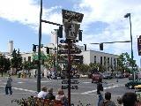
Chicago late in the morning [Picture]. As we were entering Chicago,
there was a billboard included the distance to Alaska, which was a
little weird [Picture*]. We stopped
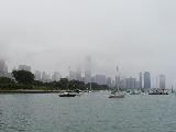
for just a few minutes to walk around the lake shore near the Shedd
Aquarium [18 Chicago Pictures] before
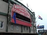
driving up to the North End for the Cubs game. [Many Pictures and much more about the Cardinals and
Cubs at Wrigley Field*] After the game, we fought the Chicago
traffic [4 Pictures] on our way to Lemont,
where we spent the evening with Ray and Kris.
Day 2 Travel Log
Day 3: June 8, 2001 |
 |
 |
We started the day in Lemont at Ray and Kris' house [Picture], leaving around 9 AM. We needed to
get a new spare tire, so we went to a nearby WalMart, and they mounted
the new tire and we were on our way at 10. We drove up through
northern Illinois [13 Pictures],
Wisconsin [15 Pictures], and Minnesota
[2 Pictures] with very nice weather -
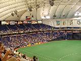
sunny and in the 70's. We made it to the Twin Cities [5 Pictures] around 5, and stopped for dinner
at one of my favorites, the Famous Dave's BBQ Shack [Picture] in Roseville. Then into
Minneapolis [8 Pictures], arriving at
the Metrodome [6 Pictures] a little
after 6 to buy tickets to see the Twins beat the Pittsburgh Pirates [Many pictures from the game*]. After the game
[Picture], we had a little trouble
finding a room, and ended up about half way to St. Cloud, at a Super 8
in Becker [2 Pictures].
Day 3 Travel Log
Day 4: June 9, 2001 |
 |
 |
We started this Saturday morning in Becker, and drove up to St. Cloud
[3 Pictures], where we stopped for gas and
at the post office to mail some items home. We drove across western
Minnesota on I-94 [6 Pictures]. We were
listening to a sports radio station from Bismarck, and before we knew
it they were doing a segment about lawn mower racing. Really. By
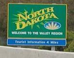
late morning, we made it to North Dakota [3
Pictures*], the 11th state on this trip and my 48th overall,
completing the Lower 48. We got lunch in Fargo [6 Pictures], drove around town a bit, and
stopped to spend a few minutes at the Roger Maris Museum, which is
actually a large display case in a mall in Fargo. We headed north on
I-29 [4 Pictures] to Grand Forks, where we
parked in the downtown area and walked by the Red River of the North,
and walked across the bridge into East Grand Forks, Minnesota, and
back [13 Pictures*]. After filling up
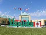
the tank, we continued north [5 Pictures] to
the 49th parallel and the Canadian border, where we entered Manitoba
[7 Pictures*]. There was a line at customs,
but it didn't take too long. Next was the ride up Rte 75 [3 Pictures] to Winnipeg, and some driving
around that city to see what there was to see (not a whole lot it
seems) [17 Pictures]. From there, we
turned west onto Trans Canada Highway 1 and the Yellowhead Route [2 Pictures]. We stopped for dinner in
Portage la Prairie at a diner-like place, and decided to call it a day
and checked into the Super 8 in Portage. We watched the Colorado
Avalanche win Game 7 of the Stanley Cup Finals on CBC.
Day 4 Travel Log
Day 5: June 10, 2001 |
 |
 |
We were on the road out of Portage la Prairie [2 Pictures] at 8 AM and headed west on Trans
Canada 1 [6 Pictures]. The road remains
a divided highway for about 2 hours, but then drops to two lanes
approaching Saskatchewan [7 Pictures]
and remains two lanes for a while. We stopped for lunch in Regina [7 Pictures] then headed north toward
Saskatoon [5 Pictures]. The roads were all
much better than expected and we made good time. In Saskatoon [5 Pictures], we had a long search for a
gas station. You'd think they'd be easy to find along the main
streets of a pretty big city, but no. After we found one, we joined
up with the Yellowhead Route and Trans Canada 16 [8 Pictures] and turned back toward the west.
We entered Alberta at Lloydminster [3
Pictures], which is a city literally right on the border. Part of
the city is in Saskatchewan and part is in Alberta. We drove on a bit
[2 Pictures] to find dinner at Sammy's
Drive In in Vermilion [2 Pictures]. We
sat next to talkative northern Albertan who doesn't like high gas
prices, high taxes, or people who cause trouble. We continued west [3 Pictures] to Edmonton, where we made
a stop to take pictures of the Wayne Gretzky statue outside the
SkyReach Center (Northlands Coliseum) [9
Pictures*] before checking in to yet another Super 8 [2 Pictures].
Day 5 Travel Log
Day 6: June 11, 2001 |
 |
 |
We started in Edmonton and needed to get the car's oil changed. We
found a Sears at the West Edmonton Mall where we figured we could get
a quick oil change and take a look around the huge mall at the same
time. Since Sears doesn't service many Audis, they had to order the
oil filter and oil and they said it would take about an hour and a
half. So we walked around the still-closed mall, checking out the
skating rink, water park, pirate ship, and dolphins. It's a mall and
an amusement park in one. But it's still a mall [15 Pictures]. Back to Sears after 90 minutes
and they hadn't even started because the auto parts place sent the
wrong oil. It was another 90 minutes although they kept telling us
"just a few more minutes". It was noon by the time we got on our way
out of Edmonton. Unfortunately, the delay cost us any chance to look
around at Edmonton before heading out.
Finally we headed West on the Yellowhead Trail and Trans Canada 16 [2 Pictures]. Not far out of Edmonton,
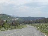
we turned north onto Alberta route 43 [8
Pictures] which would take us all the way to the Alaska Highway.
We made a lunch stop at a little restaurant near Blue Ridge [4 Pictures], the first of the many diners
of the north which all seem to have the same menu. Further up Route
43 [2 Pictures], we stopped at a small
visitors center and rest area just before Valleyview [5 Pictures]. There was some minor
construction [2 Pictures] before Grande
Prairie. We tried to stop for gas in Grande Prairie [3 Pictures*], but the only station on
our side through the whole town was too crowded. I never thought gas
stations could be so well hidden from the main road through town. So
we pushed on to British Columbia (and the Pacific Time Zone) [2 Pictures] where the road becomes BC 2 [2 Pictures]. It was just a few more miles to
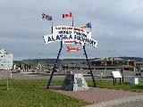
Dawson Creek, where the Alaska Highway begins. In Dawson Creek, we
filled up the tank, then parked to check out the start of the Alaska
Highway and to grab some dinner [19
Pictures*].
On the way out of Dawson Creek, we reset the trip odometer to
approximate the Alaska Highway mileposts and headed up BC 97, the
Alaska Highway [2 Pictures].
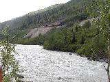
1500+ miles to Fairbanks. We stopped to take some pictures of the
Kiskatinaw River Bridge around Mile 21 [5
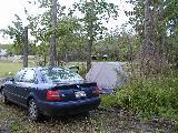
Pictures]. We were planning to camp at an RV park just past Fort
St. John [4 Pictures], but with a lot of
recent rain, the tent sites at that park were pretty much under water.
We continued a bit more up the road and found some almost dry land at
Ron's RV Park [3 Pictures*], near
Charlie Lake. We set up camp in complete daylight at around 8:30. It
was still light but dusky at 10:30 and I don't think it ever got
completely dark, here at around 56 degrees North latitude in June.
Day 6 Travel Log
Day 7: June 12, 2001 |
 |
 |
Not only does it get dark late (if you can call the dusky sky
darkness), but the sun comes up very early. The sun was up by around
4:00 AM and at 6:00 it was bright enough to make you think it was late
morning. This made it easy for us to wake up for an early start. We
were ready to go before 7:30. We stopped at a restaurant at Mile 54
(The Mile 54 Cafe, in fact) [Picture]
for breakfast and were on the road around 8. This part of the highway
is in very good shape and we were able to move right along, except for
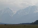
one minor construction delay. The terrain varies from mostly flat to
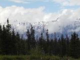
hilly, with some views of the Rocky Mountains to the west. With very
nice weather, we were able to see mountains far off in the distance [25 Pictures from between Fort St. John
and Fort Nelson*]. We stopped a couple times to take some pictures
and for a break, but we still made it to Fort Nelson before noon.
Since Fort Nelson is the only town of any significance for many miles,
we stopped for fuel, a car wash, and some lunch from Dixie Lee [3 Pictures].
Heading north (and moreso west) out of Fort Nelson, things start to
get more interesting. It becomes much more of a winding road and the
nice views are more numerous. There is a lot of recently-improved
road, much straighter and not as steep as the old road and right of
way which is still clearly visible. We made several stops to check
out the scenery [15
Pictures*], the first really major one being Summit Lake [10 Pictures*]. We saw some stone sheep [7 Pictures*], right where the Milepost
said we would, then we made a quick stop at the Toad River Cafe [3 Pictures]. The Sawteeth (a group of
triangle-shaped mountains) were interesting [3 Pictures*]. The next major thing to see
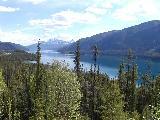
was Muncho Lake [9 Pictures*]. [2 Pictures of Horses].
We also stopped at the Liard River Hot Springs [9 Pictures*] for a little while.
At that point, we decided we could make it all the way to Watson Lake
for the night. This stretch [3
Pictures] was a bit slower, since we hit some gravel sections in
construction zones [3 Pictures]. We
made our first crossing into the Yukon Territory in a place where the
old routing of the highway crossed the border, but the new routing
doesn't seem to. But we parked and walked into the Yukon. You
probably don't think "warm and sunny" when you think of the Yukon, but
that is what we got. Sunny and about 78 [5 Pictures*] at the 60th parallel. We
continued on over a temporary bridge [2
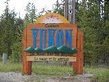
Pictures] and after crossing into the Yukon for real [3 Pictures*], we made it to Watson Lake
before 9. At over 60 degrees North, the sun doesn't set until very
late...
Day 7 Travel Log
Day 8: June 13, 2001 |
 |
 |
We checked out of the Gateway Motel [2
Pictures] in Watson Lake, then filled the
tank and picked up some
breakfast at the local grocery store [2
Pictures]. There is no doughnut shop in Watson Lake, and we
learned that since the local doughnut shop burned down, there is no
one in town who sells doughnuts (not true - I got some at the grocery
store). You can't visit Watson Lake without checking out the Watson
Lake Signpost Forest, so we did [3
Pictures]. We didn't have a sign of our own to add. West of
Watson Lake, we entered the Cassiar Mountains [8 Pictures*] and reached the Continental
Divide [6 Pictures*] a little after 10 AM.
Here, rains to the east flow into the Mackensie River system, draining
into the Arctic, and to the west, they flow into the Yukon River
system, draining into the Pacific. The Cassiar Mountains don't look
to be especially tall, but at this latitude, the tree line is about
half way up many of the peaks. Around 10:30, the road crossed back
into BC for a little while for the last time Northbound [2 Pictures]. Back in the Yukon, we
stopped to see Teslin Lake [4 Pictures],
passed the junction with Canol Road [Picture], and took assorted other pictures [4 Pictures]. We checked out Marsh
Lake [5 Pictures*] and spent some time at
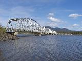
the first bridge over the Yukon River [9 Pictures]. From there, we passed
the Klondike 2 (the road to Skagway that we'll take later) [2 Pictures] before reaching Whitehorse [2 Pictures].
We checked into the River View Hotel and got a little lunch [Picture], then picked Andrew up at the
airport [Picture]. Yes, I've now picked
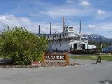
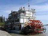
someone up at the airport in the Yukon. We walked around Whitehorse
[2 Pictures] a bit and ended up
taking the tour of the S.S. Klondike [15
Pictures*]. We walked back to the hotel along the Yukon River [3 Pictures*]. After some laundry
at the hotel [2 Pictures], we
walked to dinner at a restaurant called Cheechako's. Whitehorse is an
unusual little town. It's at over 60 degrees North and in the middle
of nowhere, but it has all the fast food chains and everything else
you'd expect from a city its size or larger in the U.S. or in southern
Canada. And yes, it stays light even later here [2 Pictures*].
Day 8 Travel Log
Day 9: June 14, 2001 |
 |
 |
We left the River View Hotel [Picture]
in Whitehorse [Picture] around 10
AM and headed on toward Alaska [Picture]. We made several stops
along the way, including the Takhini Burn area [3 Pictures*], the Canyon Creek bridge [3 Pictures*], and some Kluane National
Park sites [5 Pictures*]. Between
Haines Junction [2 Pictures] and Beaver
Creek, the construction [Picture] and
gravel breaks were far worse than the entire highway south of here, so
the going was a lot slower. But there were more nice views of the
Kluane Range [2 Pictures]. The
highway follows Kluane Lake for a while [6
Pictures*], and we stopped at Sheep Mountain [Picture]. [Picture of a Bird along the Lake]. We
made a lunch stop at Destruction Bay [3
Pictures] and passed through another burn area from 1999 near
Burwash Landing [4 Pictures]. After the
longest gravel/construction mess of the ride up [2 Pictures], we made a brief final stop
in Canada at the info centre in Beaver Creek [Picture], which is the westernmost town
in Canada. We crossed past Canadian Customs [Picture] and went on for several miles
[2 Pictures] of Canada where you can't
go back to Canada or continue on to the US without clearing customs
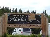
somewhere. A big milestone was arrival at the Alaska border [10 Pictures*] at 6:00 PDT, 5:00 AKDT,
where we stopped for a while for pictures. This was state number 49
for me. We continued, now on Alaska 2 [5
Pictures]. At a rest stop, we met a man in an RV who became known
as "crazy guy" for the rest of the trip. We arrived in Tok for the
night at 7:15. We checked into the Golden Bear Motel just off the
Alaska Highway on the Tok Cutoff [Picture], and got dinner from the
adjacent Golden Bear Restaurant.
Day 9 Travel Log
Day 10: June 15, 2001 |
 |
 |
We checked out of the Golden Bear [3
Pictures] in Tok, put gas in the car and picked up some brochures
at the visitor center. We didn't have that far to go, so we were able
to stop to look at things whenever we wanted. We stopped for a
viewpoint at Mile 1310, for a construction delay, and then Mile 1370
[4 Pictures]. A big milestone in
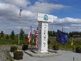
the trip came just before noon, when we reached Delta
Junction, and the Northern terminus of the Alaska Highway [11 Pictures*], 1408 miles after leaving
Dawson Creek. The visitors center there is very nice, and we spent
quite a bit of time looking around. It includes newspaper clippings,
photos, and diary entries from the construction of the highway.
We got lunch at the Buffalo Center Diner [Picture], then headed a few miles down
the Richardson Highway [3
Pictures] for a tour of Alyeska Pump Station No. 9 on the Alaska
Pipeline [4 Pictures*]. This tour was
very interesting, bringing us right inside the pump station where we
heard a lot about the pipeline and got a very thorough tour of how the
station works. On the way back up to Delta Junction, we stopped for
some pictures of the Alaska Range [4
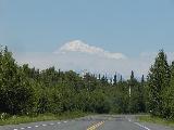
Pictures]. [One more DJ picture] The
ride from Delta Junction was great, with lots
of impressive views of
the Alaska Range and the Alaska Pipeline crossing the Tanana River via
suspension bridge [4 Pictures*]. We
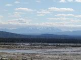
stopped to look at the Alaska Range at Mile 288 and again at Mile 296.
We thought the view at 287 was good until we were at 296 and saw the
clouds starting to break up, exposing the very impressive peaks of
Hayes, Hess, and Deborah [9
Pictures*]. Closing in on Fairbanks, we passed Eielson Air Force
Base [4 Pictures] and passed through North
Pole, where we saw a giant Santa Claus [3 Pictures] and a large gate painted like candy
canes, which actually is the front gate for a welding company.
We arrived in Fairbanks [2 Sign
Pictures] at the Golden North Motel around 6:00 PM. The trip
odometer showed 1523.8 miles -- 1523 is exactly the historical mileage
from Dawson Creek to Fairbanks on the original Alaska Highway. We got
a nice dinner at the Alaska's Castle restaurant [2 Pictures]. After dinner, we drove up to
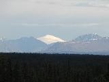
the University of Alaska-Fairbanks campus, where there is a viewpoint
of the Alaska Range [9 Pictures*]. The
view from here is absolutely amazing, stretching across what seems to
be the entire Alaska Range, including Denali. Unfortunately, it is
pretty much impossible to capture it on film, so you have to go see
the view for yourself (yes, go!). We went back up there a little
after midnight to see the mountains close to sunset [5 Pictures*]. The view was still
spectacular, though even harder to capture in a picture.
Day 10 Travel Log
Day 11: June 16, 2001 |
 |
 |
Another nice day in Fairbanks -- forecast to go up into the 70's with
sun. It was interesting to watch the local forecast on the Weather
Channel and see "TONIGHT...MOSTLY SUNNY. LIGHT WINDS. LOWS IN THE
UPPER 40S TO LOWER 50S." But with only 2 or 3 hours of relative
darkness, "mostly sunny" is appropriate for an overnight forecast. We
had errands to do in the morning, with a badly needed car wash and a
laundry stop for Andrew [3 Pictures]. We
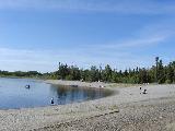
got lunch at the Golden Shanghai, a Chinese buffet [3 Pictures]. We decided to head out
through North Pole [3 Pictures] and
checked out the Chena Lakes Recreation Area [6 Pictures*]. We didn't expect an
afternoon at the beach on a trip to Alaska, but that's what happened.
It could have been a state park with a lake and a beach anywhere in
the Lower 48. We got back into Fairbanks and went for dinner at Los
Amigos, a local Mexican place [2
Pictures]. We chose it because it was supposed to have some of
the "best dark in town", something you don't think you want until you've
spent too much time in daylight. On the way back, we stopped to check
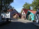
out Alaskaland [9 Pictures*]. This is
not a typical theme park, more of a historical exhibit with shops and
other things to do. We talked to a woman in the Cache Creek shop
about various Alaska-related things, and Andrew did some panning for
gold.
Day 11 Travel log
Day 12: June 17, 2001 |
 |
 |
[2 morning pictures at the motel].
This was our last full day in Fairbanks, so we had to pick the things
we most wanted to do. Unfortunately, a tour to the arctic circle
wasn't really possible, but we found things to do locally. We spent
some time in the morning at the University of Alaska Museum, which has
a good number of Alaska-related exhibits [13
Pictures*]. We tried to get lunch at Pike's Landing, but it was
too crowded with the Fathers' Day brunch people apparently out in
force. We had tickets for the 2:00 PM sailing of the Riverboat
Discovery, so we needed something fast and ended up at Wendy's [Picture], our first fast food stop since
Fargo, and our only fast food chain visit while outside the lower 48.
We made it back to the Riverboat Discovery in time, and had a nice
tour of the Chena and Tanana Rivers aboard Discovery III, along with
several busloads of senior citizens [43
Pictures*]. With the long, sunny day, it was still warm after the
cruise as we headed back to the motel [2
Pictures*]. We went to dinner at Pike's Landing [Picture], and it was still crowded, but
little did we know that we'd be there for almost 2 hours in the late
evening sunshine. We got back to the motel [Picture] around 10, but it was still
broad daylight, now just a few days from the longest day of the
year.
Day 12 Travel Log
Day 13: June 18, 2001 |
 |
 |
This was Fairbanks to Denali day. Another warm and sunny day. We
checked out of the Golden North in the morning and went into downtown
Fairbanks [3
Pictures] to check it out
and to look for some souveniers. We saw the park by the riverfront [5 Pictures*], a museum with a lot of
historical information about the development of Alaska and the Yukon
[2 Pictures], and had lunch at
the Co-op diner in downtown Fairbanks [Picture]. We left Fairbanks and headed down
the Parks Highway toward Denali [13
Pictures*]. There were views of the Alaska Range and the Tanana
and Nenana Rivers [14 Pictures*] . We
passed the Denali National Park entrance [Picture] and arrived at Carlo Creek
[Picture] mid-afternoon and checked
into the Denali Mountain Morning Hostel and Lodge [2 Pictures]. Our hosts Ben and Becky were
busy working on some new cabins. We had a private room in the lodge,
with a common area downstairs for sitting and cooking and whatever
else, though we didn't really use it. We headed back north to the
Denali National Park visitors center [3 Pictures*] to buy tickets for a bus
trip into the park tomorrow. We couldn't get on a bus all the way
back to Wonder Lake, but we did get a reservation on a bus to the
Eielson visitors center for late morning. We heard there were good
views of Denali (especially on a mostly clear day) from the Cantwell
area, so we went down there and made the ride several miles up the
Denali Highway (Alaska 8) [12
Pictures*]. The views were great, although some parts were in the
clouds. We looked around Cantwell [3
Pictures], and it seems there isn't much to the village. We got
dinner at the Tsesyu Time to Eat cafe [2
Pictures] near the junction of the Parks and Denali highways. We
got back to the lodge [3 Pictures*]
around 8 for the night.
Day 13 Travel Log
Day 14: June 19, 2001 |
 |
 |
This was Denali day. We left the Lodge in the
morning [8 Pictures*] and headed up
to the village of McKinley Park in search of breakfast. We ended up at a
buffet at the Denali Park Resort, then went across the street to the
general store to get food to get us through the day. We got into the
park [2 Pictures] and were on our bus
[Picture] by around 11 AM. We wanted
the 11-hour tour to Wonder Lake, but those were sold out, so we got
the 8-hour tour to the Eielson Visitor Center at Mile 66 of the park
road. This shuttle bus follows the park road back and stops for
wildlife when something good is out there, and for a few rest stops.
Our bus driver, Rick, gave some great commentary and helped to pick
out some good wildlife on the way out. We didn't see much wildlife on
the first leg of the trip, but the scenery was nice [2 Pictures]. The first rest stop
was along the banks of the Teklanika River, about 90 minutes into the
ride [5 Pictures*]. Wildlife was
still in hiding, but the scenery stayed nice [2 Pictures]. We finally came
across our first wildlife sighting when someone noticed some Dall
Sheep up on a mountain [4
Pictures]. [2 Pictures
crossing a river]. Into the Sable Pass area [3 Pictures*], things started to
get more interesting. The first relatively close wildlife was a
caribou off to the side of the road [4
Pictures*]. Next was the Polychrome area [3 Pictures], with brightly colored
mountains, and our second rest stop [10 Pictures*]. Right after leaving
the rest stop, we ran into some more dall sheep, but these were much
closer [2 Pictures*]. Then a
ptarmigan [2 Pictures*]. Then
more caribou [3 Pictures]. Then a
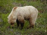
pretty descent into the Toklat River valley [2 Pictures]. Then our first bear [3 Pictures*]. Then our first fox [3 Pictures*]. Not bad.
The stop at the Eielson Visitor Center [2 Pictures] is the longest, but is
still only 30 minutes. I took a short walk down a trail to take more
pictures [13 Pictures*].
We decided to stay a little longer and take a later bus on out. This
gave us a chance to do a short (but steep) hike up the mountain across
the roads from the visitors center [24 Pictures*]. This gave us
our best views of Mt. McKinley, but even then it was mostly in the
clouds. In fact, it rained some while we were at the visitors center.
When we got back and signed up to get onto one of the buses, we were
not happy to learn that it would be at least an hour before a bus had
space. So...more time to take pictures at Eielson [5 Pictures*].
Lucky for us, we got onto what was probably the best bus of the day,
maybe of the month. Our new bus driver's name was Peter, and he was
also great. He was helped by the fact that we encountered one
outstanding wildlife sighting after another. It started with a group
of three bears - a mother and two cubs, and right by the road [30 Pictures*]. Then a large caribou [Picture]. Then a fox walking down
the road in front of us [3
Pictures*]. We made the scheduled stop at the rest area on the
Toklat River and got to walk down into this braided river basin [3 Pictures*]. Then a closeup
view of a collection of rams - male dall sheep [11 Pictures*]. I also have some pictures
which attempt to convey how narrow the road is and how steep the banks
are down to the river far, far below [2
Pictures*]. This place really would have problems if they did let
people take their own cars on the Park Road. We stopped to check out
a fox den, and got to see 4 young foxes out playing in front of the
den. Throw in a grizzly bear on the ridge above the den and some dall
sheep on the top of the mountain behing them, and we had quite a scene
[4 Pictures*]. While Peter was
telling an interesting story about wolves, one of the few animals we
hadn't yet seen, someone in the back of the bus noticed a lynx off to
our left. Lynx are some of the hardest to spot, being nocturnal and
generally pretty easily scared away. But we definitely got to see one
and followed him down the road just a bit as Peter coasted forward
quietly. I was on the wrong side of the bus and my pictures of the
lynx didn't come out, but my attempts are here, along with Rob's
successful picture of the lynx [5
Pictures*]. One more rest stop [2 Pictures] and then one more
fox [Picture] in the road and
the tour was complete. With all the wildlife, the bus was a little
late, and it actually arrived back at the park entrance after 10 PM.
We ended up getting dinner at a pizza place in McKinley Park and
finally got back to the lodge to move into the overflow bunk room
around 11:15.
Day 14 Travel Log
Day 15: June 20, 2001 |
 |
 |
We left Ben and Becky's Lodge and Hostel in Carlo Creek and headed
South toward Anchorage. This was a bright and sunny morning, giving
some hope of seeing Denali on the way down the Parks Highway. We
stopped in Cantwell for breakfast at a familiar place - Tsesyu Time to
Eat Cafe and to fill the tank. We stopped along the way several times
to attempt to get pictures of Denali. We stopped at viewpoints 9
miles [3 Pictures*] and 27 miles
[2 Pictures*] south of Cantwell,
and also passed Summit Lake [Picture*]. The view of the
mountains from Hurricane Gulch was great [5 Pictures*], and we probably got a
look at Denali. The viewpoints in Denali State Park were nice. At
the North viewpoint [6 Pictures*],
Denali was pretty much in the clouds. [Construction Picture]. At the
South viewpoint, the base of McKinley was in clouds, but parts of the
peak were poking out of the clouds, so we stuck around to try to get a
better view [12 Pictures*].
Fortunately, as we continued south, the views
were great, and we got
some great looks at the entire upper part of the mountain from the
road [2 Pictures*]. We also stopped
at a viewpoint which was nice, but didn't have a Denali view and did
have tons of mosquitos [3
Pictures]. Then one more nice view from the highway [2 Pictures*].
We continued South to the end of the Parks Highway and decided to get
a room in Palmer before heading into Anchorage for a few hours. We
checked into the Alaska Choice Motel [2
Pictures], then headed south on the Glenn Highway [3 Pictures] into Anchorage [2 Pictures]. We parked in the
downtown area [3 Pictures*], walked
to Resolution Park [8 Pictures*],
then around downtown where we picked up some souveniers [4 Pictures]. We had a nice dinner
at the Pepper Mill restaurant [Picture].
After dinner, we drove over to Earthquake Park [10 Pictures*], where it was "bugging",
then did a little shopping [Picture] before
heading back out to Palmer for the night [7 Pictures].
Day 15 Travel Log
Day 16: June 21, 2001 |
 |
 |
Solstice Day in Alaska. We started out in Palmer with a goal for the
day of reaching Tok. We had thoughts of making a side trip to Valdez,
but that turned out to be too much, and we went pretty much straight
from Palmer to Tok. The Glenn Highway starts by following the
Matanuska River [2
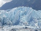
Pictures]. Then we reach the river's source - Matanuska Glacier. We first observed it at
viewpoints along the highway [6 Pictures*], then went out
and walked on it at Glacier Park [First 12 Pictures*][Next 12 Pictures*][Last 12 Pictures*]. [Rob's Matanuska Pictures*]. This was really
amazing, as we were able to park near the bottom of the glacier and
hiked across the rocks, mud, and ice to get to the real white and blue
ice part of the glacier. Yet another outstanding stop. We got lunch
shortly afterward at the Long Rifle Cafe [Picture], with a nice view of the glacier.
We continued to have good views of the Chugach Mountains [3 Pictures*] to our south. After
Eureka Summit [6 Pictures*] and as we
approached Glenallen, peaks of the Wrangell Mountains [2 Pictures*] appeared to our
east. Throw in the occasional view of the Alaska Range to the north,
and this is a pretty specacular drive. The first of the Wrangell
group that we got to see was 12,000 foot Mount Drum, which sits just
east of Glenallen. An Alaska thunderstorm blocked our views for a
while, but we had some really nice looks at the Wrangells.
After a brief stop in Glenallen [5
Pictures], we made a side trip south on the Richardson Highway, in
the direction of Valdez. Given time constraints, we only went as far
as the Visitors Center for Wrangell-St. Elias National Park and
Preserve [Picture]. We were told not
to expect to see much with the clouds, but as we headed back north to
a viewpoint near Glenallen, we got views of both Mount Wrangell and
Mount Blackburn, in addition to Drum and Mount Sanford [8 Pictures*]. Heading north and
east out of Glenallen, the road is being rebuilt this summer, and the
current project seems to be to replace every culvert, leaving dozens
of short, annoying gravel breaks [Picture], right up to the junction
with the Tok Cut-Off [Picture].
Sanford is a very impressive volcano that we could see much of the way
to Tok, dominating the wonderful view to the south. We stopped for
pictures at the Copper River (both 1 mile [Picture] and 24 miles [Picture] from the junction), took
more pictures from the car [2
Pictures], and stopped again at the Cobb Lakes viewpoint [3 Pictures]. We made another stop
for Wrangell views [2
Pictures*], and I have a picture from near Mentasta [Picture]. [Picture of a Bear-like Dog]. We got to Tok
around 8:00, checked into the Snowshoe Motel, got dinner at Young's
Cafe, then did our laundry at a Texaco station. As this is being
typed, it is midnight and still light on this longest day of 2001,
despite the sun being behind the clouds.
Day 16 Travel Log
Day 17: June 22, 2001 |
 |
 |
We left the Showshoe Motel [Picture accidentally deleted] in Tok and
headed south and east on the Alaska Highway [Picture]. We arrived at the
Canadian border a little after noon and crossed back into the Yukon
and into Pacific Daylight Time [5
Pictures*]. We got lunch in Beaver Creek from Ida's [Picture], and also stopped for other stuff at
the Mile 1202 Store and picked up a GST refund form at the visitors
centre. This was our only significant backtracking west of Chicago,
so we have fewer pictures from this day. We stopped for a break at an
overlook of the Kluane Icefield Ranges [4 Pictures*]. The biggest
difference we noticed since our trip northbound 8 days earlier is that
the wildflowers really came out since then [3 Pictures*]. We stopped again at Sheep
Mountain [5 Pictures], and ran into
a lot of gravel breaks where the road is being rebuilt this summer [2 Pictures*]. In Haines Junction [3 Pictures], we filled the tank and got
dinner at Wong's at the Kluane Park Inn [Picture]. From there it was on to Whitehorse,
with just a quick stop in the rain at the Takhini Burn viewpoint [5 Pictures]. We checked back into the
River View Hotel in Whitehorse [Picture].
Day 17 Travel Log
Day 18: June 23, 2001 |
 |
 |
We started the day in Whitehorse, and Rob and I left to catch the
ferry in Skagway, while Andrew stayed behind for his flight back home
out of Whitehorse. The ferry requires a check-in at 11:45, so we got
on the road pretty early. After a stop at the local Tim Horton's for
breakfast, we got going. The ride from Whitehorse down Klondike
Highway 2 is very scenic. It cuts south off the Alaska Highway just
east and south of Whitehorse [2
Pictures] and follows the path of the Klondike gold rush of 1898.
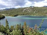
First comes Emerald Lake, a small lake with bands of green and blue,
caused by white sediment on its bottom [4
Pictures*]. Then Carcross Desert, which is essentially a big sand
dune that has thin vegetation [6
Pictures*]. We passed Carcross, a small town at the junction of
Klondike 2 and the Tagish Road [2
Pictures]. Then it was on up toward White Pass. We stopped for
pictures at Bove Island [4 Pictures*].
We passed some old mining equipment in the southern Yukon [7 Pictures*], then crossed into British
Columbia [Picture]. We also stopped at
the Chilkoot Trail National Historic Site [4
Pictures]. This section of highway doesn't really serve any
significant towns in BC and it looks like it's maintained by the
Yukon, based on some of the signs we saw. Just before the big climb
into the pass, we went through the small town of Fraser, where Canada
Customs is for northbound travellers. Then up into the wonderful
scenery - lots of snowy, rocky mountains and small lakes and rivers.
Once we got above the tree line, there was smaller vegetation and
still large patches of snow. We stopped a few
times for pictures, 9 miles [3
Pictures*], 6 miles [4 Pictures*], and 1
mile [3 Pictures*] north of the border. The
summit of the pass is the actual border crossing, reentering the US, Alaska,
and the Alaska Time Zone [14 Pictures*].
Here, some of the moist air from the ocean side of the mountain sneaks
through. On the way down the American side,
there is heavier and what
seems to be more temperate vegetation (more deciduous trees). We
crossed an unusual suspension bridge [2
Pictures*], cleared U.S. Customs [Picture], then got views of the White Pass
and Yukon Route Railroad [3 Pictures*] as
we descended into Skagway.
Skagway itself is a picturesque little town
surrounded by snow-capped
mountains with a small waterfront [12
Pictures*]. We parked and walked around for just a little while,
picking up lunch from Fat Franks, a small deli. We didn't have time
for much else in Skagway, since we had to check in at the ferry
terminal [4 Pictures]. While in
line to check in, it was a little disturbing to see all three ticket
windows close up with customers in line, but it seems the ticket
window people are also responsible for helping tie down the boat when
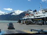
it docks. But we checked in successfully and put the car in line.
We started boarding on the M/V Matanuska shortly before 1 [6 Pictures*]. You drive your own car onto
the ferry here and then carry your bags up to the main decks. We sat
out on the solarium area while the rest of the passengers boarded [9 Pictures*]. Once we got started, we were
able to check in to get our cabin, freeing us up to walk around some
more without worrying about the luggage. The trip from Skagway to
Haines is only 13 miles and took about an hour [9 Pictures*]. We didn't get off the
boat at the ferry terminal in Haines, since it's 4 miles from town,
but we did get some pictures from the boat, including some bald eagles
[6 Pictures*]. There was a nice
view of Haines and the surrounding area while the ferry was pulling
away [8 Pictures*]. After leaving Haines,
we were able to check into our cabin [Picture]. During the late afternoon, we got
to see some humpback whales and porpoises during a talk by the forest
ranger assigned to the boat [4 Pictures*].
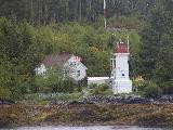
We passed the first of many lighthouses at Eldred Rock [4 Pictures*] and more scenery worthy of
pictures [2 Pictures]. We decided to avoid
the dinner rush when they opened the cafeteria at 6:00, and what a
rush it was, waiting until around 7 to eat. We missed the line, but
unfortunately, the selection was thin after the big crowd at the start
of dinner. A little after 8, we approached Juneau, getting some nice
views of the lighthouse at Sentinal Island [2
Pictures*], Mendenhall Glacier, and the Auke Bay area of Juneau [5 Pictures*].
The ferry doesn't come close
enough for a view of the Juneau city center. We were able to get off
the boat for about a half hour when we docked, but there wasn't
anything in walking distance except the ferry terminal itself [6 Pictures]. The good news is that
a lot more people got off the boat than got on at Juneau, so the rest
of the way the boat would be much less crowded. Most notably, a tour
bus left, freeing up many seats in the lounges on board. After the
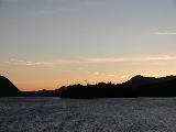
stop, there was one last spectacular sight for the day - a deep orange
sunset over the mountains and water to the Northwest as we pulled away
from Juneau [12 Pictures*], one of the best
you'll ever see.
Day 18 Travel Log
Day 19: June 24, 2001 |
 |
 |
Day 2 on the ferry. There was a brief early morning stop in
Petersburg, but long enough to take some pictures of the town from the
boat [4 Pictures]. [Additional Boat Picture]. We made a bit
longer stop in Wrangell [10 Pictures*]
around mid-morning, and there we were able to walk around town a bit.
Being Sunday morning, nothing was open, but at least we saw a bit of
the town. There were no stops in the early afternoon [6 Pictures]. As we continued south toward
Ketchikan, we passed another lighthouse [2
Pictures], the clouds thickened and the rain started [5 Pictures]. This is only right, since
Ketchikan is a very rainy place. We arrived in Ketchikan [4
Pictures] for our longest stop
of the trip and it was raining steadily. We got off the boat [11 Pictures*] and walked over a mile south,
but were unable to get to the city center before we had to turn around
to catch the boat again. We did get to make a grocery store stop, at
least, and picked up some newspapers. Ketchikan is a surprisingly big
city, well worth a visit next time. Continuing south [5 Pictures], we left the Inside
Passage during the evening into the open waters of the Pacific for a
little while at Dixon Entrance [2 Pictures].
This made the boat sway a bit more, but nothing too severe. After
dark, we passed near Prince Rupert, BC [2
Pictures], but didn't get close enough to see anything but lights
at the shore.
Day 19 Travel Log
Day 20: June 25, 2001 |
 |
 |
This is the full day on the ferry - no stops. [2 Pictures of a house on a rock]. We
passed one ocean crossing during the morning [2 Pictures], then came a picturesque
lighthouse and the town of Bella Bella, BC [7 Pictures*]. We passed by a BC Ferry
called Queen of the North going the other way [2 Pictures]. The crew of our boat performed
a weekly fire and lifeboat drill early in the afternoon [6 Pictures]. The second ocean crossing, of
Queen Charlotte Sound, was a little rougher, but not bad [7 Pictures*]. After that, we were behind
Vancouver Island [Picture] for the
rest of the trip. We passed a barge hauling all kinds of stuff
Northbound [3 Pictures*]. The views of
coastal BC were very nice, especially when the rain stopped and the
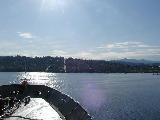
sun came out for the afternoon [8 Pictures*].
There was an interesting video about the demolition of Ripple Rock in
the area we were passing through, but it was not obvious when we got
to the site. Later, we got another nice sunset in the north [10 Pictures*], giving way to the darkest night
[Picture] for us in quite a while, with
actual stars visible, especially to the south.
Day 20 Travel Log
Day 21: June 26, 2001 |
 |
 |
The ferry arrived in Bellingham [13
Pictures*] around 8:30 AM PDT. It didn't take long to get things
into the car and we were on our way. We filled up the car with
relatively cheap gas and headed down Interstate 5 [6 Pictures]. We were delayed by two accidents
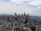
but got to Seattle by mid-morning. Our first
stop was the Seattle
Center, where we went up the Space Needle [13
Pictures*]. There were some clouds around, but we could still see
Mount Rainier and Mount Baker. Next was lunch from a Mexican place
downtown [Picture], a ride around the
Safeco neighborhood in downtown [16
Pictures], then a visit to Cray to meet up with Nathan. We walked
with him and some others from Cray up to the Pike Place Market as they
got lunch (and we got ice cream) [12
Pictures*]. Rob and I walked around the waterfront for a while,
then went to pick up Nathan back at Cray. We went to Andrew's on
Mercer Island [3 Pictures] to drop
off some of his things from the trip that we brought back for him and
stayed there for a little while. Then it was off [8 Pictures] to dinner at Olympia Pizza II in
the Wallingford section of Seattle on 45th Ave. N. After that, it was
an Imax movie about Mt. St. Helens at the Seattle Aquarium [5 Pictures], then back to Nathan's in the
Magnolia section of Seattle.
Day 21 Travel Log
Day 22: June 27, 2001 |
 |
 |
We left Nathan's around 8:30 and started the big ride back east.
Before 9, we were on I-90 East [6
Pictures], and there to stay for much of the ride home. We made a
few stops for gas and food, but that's about it. The ride through
Washington was rainy, but not too bad, right up through Snoqualmie
Pass [Picture]. When we got to the dry
side of the Cascades, it was mostly just cloudy [12 Pictures*]. Into Idaho [4 Pictures], the rain picked up. On the way
up the west side of Lookout Pass, the rain kept getting more and more
intense, to the point where we had wind-driven sheets of rain and
standing water on the highway [7
Pictures*]. This continued into the first several miles of
Montana, but we were able to get ahead of the storm and moved into
sunny weather for the late afternoon. If you've travelled I-90 in
Western Montana, you know about Clark Fork, so we stopped to take some
pictures [3 Pictures]. [13 More Pictures in Western Montana]. We
stopped for dinner at a pizza place (with a casino, like everything
else in this part of the country, it seems) in Butte [3 Pictures]. After Butte, we climbed to the
Continental Divide and what I believe to be the highest point on I-90
[5 Pictures*]. We reluctantly passed the
exits for Yellowstone [Picture] and
decided to go for Livingston as a desintation and ended up at the
Comfort Inn there.
Day 22 Travel Log
Day 23: June 28, 2001 |
 |
 |
We started early from Livingston [Picture], since we wanted to make sure we
got to see both Mount Rushmore and the Badlands and still get into a
motel on the other side before too late. We were able to move right
along for the most part in Montana, with just a few minor construction
delays and a gas stop in Billings [7
Pictures]. We considered the Little Bighorn National Battlefield
[Picture], but thought better of it
given time constraints. Next time. We crossed into Wyoming [Picture] and drove along the east front of
the Bighorn Mountains [5 Pictures*] to
Buffalo [4 Pictures], where we got lunch
from a local sub shop [Picture]. We then
turned east, getting a few glimpses of Devils Tower off to the North,
but again we passed up a chance to visit it up close because of time
[4 Pictures].
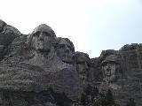
We filled the tank just before crossing into South Dakota [Picture]. There, we cut down through the Black
Hills via Deadwood [7 Pictures*] and
Keystone to Mount Rushmore [13 Pictures*].
[Rob's Rushmore Pictures]. We hit a
thunderstorm with some small hail as we were getting close. It was
still storming when we got there, but the sun was out after we
finished looking around the inside of the visitors center. So we did
the 6/10 mile trail to the base of the mountain to take some more
pictures before moving on [2 Pictures].
It was on up through Rapid City out to Wall, where we made the
required stop to show Rob what Wall Drug is all about [7 Pictures*], and got some dinner at the
Wall Drug Cafe.
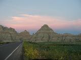
From there, it was on into the Badlands National Park [2 Pictures]. It was getting late by this
point, and we didn't have much sunlight left. The good news is that
the colors in the Badlands really come out at dusk, so things looked
extra nice. The sun was still up when we got to the park and the
Pinnacles Overlook [3
Pictures*]. The shadows were growing when we made it to the Yellow
Mounds [3 Pictures*]. Next
stop was at the Burns Basin overlook [5 Pictures*] where we also
encountered a snake to add to the extensive list of wildlife on the
trip. A little before sunset, we made it to the Prairie Wind overlook
[5 Pictures*], and stayed
around to wait for sunset on the recommendation of a photographer who
was waiting there [5 Pictures*].
We continued East on the Badlands Loop at dusk and saw Badlands colors
at their best [9 Pictures*]. [Rob's Badlands Pictures]. We left the Badlands
as it was getting dark, and checked into the Super 8 in Kadoka, just
about 20 miles down the road.
Day 23 Travel Log
Day 24: June 29, 2001 |
 |
 |
With the main sightseeing behind us, it was time to try to get home in
the next two days. We left the Super 8 in Kadoka [Picture], and headed east on a foggy I-90 [2 Pictures] across South Dakota. The fog broke
in about an hour. We passed through the famous town of Oacoma [4 Pictures] (famous to Massachusetts Turnpike
drivers, anyway -- see the 1999 trip log for more), crossed the
Missouri, and stopped at the rest area and scenic view above
Chamberlain [7 Pictures*]. We
continued east to Sioux Falls, where we switched to I-29 South [4 Pictures] to take a different route than I've
done on previous trips. We reached Iowa [Picture] at Sioux City around lunch time, and
crossed over into South Sioux City, Nebraska, to find lunch and to
fill up the tank [5 Pictures]. We
crossed right back into Iowa and continued south on I-29 [2 Pictures]. Just north of Council Bluffs and
Omaha, we turned onto I-680 [3 Pictures], a
short cut to I-80 East. We crossed Iowa on I-80 [13 Pictures] with quick stops in Avoca and
at a rest area east of Des Moines. We filled the tank and got some
food in Davenport, Iowa, and decided at that point that it would
probably be better to push on through the night instead of getting a
room somewhere and having a short night of sleep and a long day of
driving tomorrow. We took I-74 [2 Pictures]
through the Quad Cities and crossed the Mississippi. The river looked
like it was a bit out of its banks. We were surprised by the Illinois
welcome signs. There were actually two of them and they actually said
things like "Welcome to Illinois" [6
Pictures*]. This is not normally a surprise but each time I have
entered Illinois in the past (I-90 in Chicago and I-70 in East
St. Louis) there has been either no sign or just a sign like "Illinois
State Line". Anyway, we were welcomed nicely to Illinois. We
rejoined I-80 to cross Illinois [5
Pictures]. When we got south of Chicago, we hit some heavy
traffic and some construction which probably took us almost an hour to
work through. The first part, just after we merged in with I-294 [2 Pictures], seemed to be strictly volume
and merging traffic. Then when we got to the Indiana line, it was a
lane drop for construction. Once we reached the Indiana East-West
Toll Road, we left Chicago traffic behind and started to cover some
ground again. [Picture] We were at Mile
103 of the Indiana East-West Toll Road when midnight came.
Day 24 Travel Log
Day 25: June 30, 2001 |
 |
 |
We continued across Indiana, and stopped for gas and one of the many
driver switches at the Porter Travel Plaza. We entered Ohio at 1 and
it became 2 as we were now in the land of daylight savings time. We
made a couple of quick driver switches then decided to take a longer
break at Mile 100 of the Ohio Turnpike around 3:45 AM. We stayed for
about 2 hours, just enough to get refreshed a bit and for the morning
sunlight to start to take effect [Picture]. Since it was early on a Saturday
morning, we took a scenic route through Cleveland, taking Route 2
along the waterfront and between downtown and the new Cleveland Browns
Stadium [7 Pictures*]. We made a
breakfast stop before entering Pennsylvania. In PA, we made another
quick stop then moved onto New York [Picture]. We filled the tank in
Fredonia and made stops at a few service areas to switch drivers. The
Thruway [2 Pictures] was busy and the
service areas were especially crowded [Picture], probably because this is the start
of a holiday week for many people. We drove through a thunderstorm
with a lot of lightning and heavy rain west of Canajoharie, then made
a stop in Colonie for some food from Pizza Mare [3 Pictures]. We dropped some of Rob's stuff
off in Troy [2 Pictures] then continued east
[14 Pictures]. We stopped in Pownal,
Vermont, to fill the tank and arrived in Williamstown before 5:00 [Picture*].
Day 25 Travel Log
Some Stats
- In 25 days, we covered 9435 miles, visiting 19 states, 4 Canadian
provinces, plus the Yukon territory. This doesn't count a 3-day ferry
ride from Skagway to Bellingham, a trip of around 1500 miles. So call
it 11,000 miles covered.
- We also covered a lot of latitude and longitude. We started and
finished at our easternmost point in Williamstown, at 73°12' West
longitude. Our westernmost point was at the Eielson Visitor Center in
Denali National Park, which is around 150°45' West longitude. Our
southernmost point was somewhere on I-90 in Ohio, probably around when
we passed south of Sandusky, where the highway looks to go around
41°18' North latitude. Our northernmost point was in Fairbanks,
possibly when we were at the University of Alaska-Fairbanks Museum.
The latitude there is 64°51' North. Yes, about a degree and a
half from the Arctic Circle.
- We burned 322 gallons of fuel for a mileage of 29.3 MPG.
- Our shortest travel days were those on the ferry, at least in
terms of driving, and the longest was the second-to-last day when we
neared 1000 miles. In the 24-hour period from our departure from
Kadoka, South Dakota, to Northwestern Pennsylvania, we covered 1321
miles, for an average speed over 24 hours just over 55 MPH. No, we
didn't stop much.
- We didn't repeat any fast-food chains throughout the trip, but we
did eat twice at the small Time to Eat Cafe in Cantwell, Alaska.
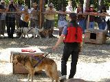
- Wildlife encountered included deer, sheep, goats, a ptarmigan,
bears, caribou, moose, marmots, ground squirrels, foxes, a lnyx,
whales, porpoises, bald eagles, bison, and a rattlesnake. And several
million small bugs, many of which may be stuck to parts of the front
of my car forever.
Thinking about doing this kind of trip? Do it!
Jim Teresco - E-mail domain: teresco.org, username: terescoj+pics --
Tue Jun 10 16:02:44 EDT 2008
Copyright notice: All images are copyright © James D. Teresco unless otherwise specified. Unauthorized use is prohibited.