Northern States Road Trip - July 7-22, 2003
This is the travel log from a trip Cathy and I took across
the northern tier of the United States, from Williamstown,
Massachusetts, to Yellowstone National Park, and back. As usual,
there is more detail and there are more pictures of roads and signs
than most people would want. The pictures are linked from within the
text below. The pages containing the pictures that I think are the
most interesting are marked with an asterisk. Most of the pictures
that are just roads or road signs have been relegated to pages listed
as "Just Sign Pictures". There are also a good number of pictures of
lichens, to be used in Cathy's middle school science classes.
These pictures were taken with my Olympus C730 Ultra Zoom digital camera.
Most images are shown at a resolution of 640x480, but are available
in 1024x768 and full 2048x1536 sizes by clicking on the links after
the captions.
The Plan
The plan came about during Cathy's visit to the Massachusetts in the
spring. It started as a trip around the Great Lakes area but
gradually expanded to include Yellowstone as the primary destination,
with stops to see other interesting things along the way across the
northern states. We packed a lot into the plan, including the UP of
Michigan, northern Minnesota, Theodore Roosevelt National Park,
Yellowstone, the Grand Tetons, the Black Hills, and the Badlands. By
the end, it included a few not-so-northern states, too, as we ended up
making a side trip through Kansas City and St. Louis on the way
home.
The Trip
Monday, July 7, 2003
|
 |
 |
I started in Williamstown and went into the office at Williams for a
couple of hours in the morning, then it was on to Troy for a couple of
meetings at RPI. I moved on to Amsterdam by late afternoon, where I
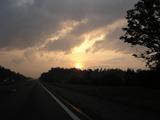
met up with Cathy for the rest of the trip. We got on the road from
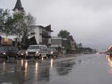
there around 5, and passed through some heavy rain along the Thruway
before things cleared up a bit by sunset [4
Pictures]. We got to Niagara Falls, New York,
checked in, then
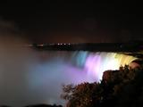
headed toward the falls. We parked on the street near the Rainbow
Bridge and walked across [Picture] to the
Canadian side for the best views of the Horseshoe Falls [14 Pictures*]. They were lit up in colors
for most of the time while we were there, but on the way back across
the bridge, the lights were changed to plain white [2 Pictures]. [Just
Sign Pictures].
Day 1 Travel Log
Tuesday, July 8, 2003
|
 |
 |
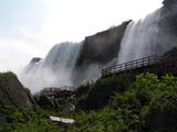
We spent the morning on Goat Island in Niagara Falls State Park, where
we looked at the Horseshoe Falls from the American side [12 Pictures*] and did the Cave of
the Winds tour. This tour involves an elevator ride down and a walk
on wodden boardwalks right up to the bottom of the Bridal Veil Falls
[25 Pictures*]. After that, we went
back up to look at the American Falls and Bridal Veil Falls from Luna
Island [10 Pictures*], and finally over to
the Three Sisters to see the rapids [9
Pictures*]. From there, we drove up to the end of I-190 to take
the bridge across into Canada. We made a stop at the viewpoint over
the Whirlpool [3 Pictures*], then down
the Niagara Parkway through Niagara Falls, mostly along the river to
the Peace Bridge, where we crossed back into the U.S. to head for
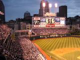
Cleveland via I-90. We got to Cleveland in time to get into Jacobs
Field for the end of Yankee batting practice [4
Pictures], but BP was cut a bit short when a thunderstorm moved
in. This delayed start of the game for an hour [9 Pictures]. Once it got underway, it
was a very quick game, as the Yankees were shut out by Billy Traber on
a one-hitter [20 Pictures]. We hit little
traffic on the way out, then continued on to our destination in North
Ridgeville, a little west of Cleveland. [Just
Road Signs].
Day 2 Travel Log
Wednesday, July 9, 2003
|
 |
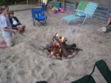 |
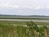
We started out from North Ridgeville and drove through some rain along
the Ohio Turnpike. Things dried out as we turned north through Toledo
and into Michigan [Picture]. We
stopped for lunch in Ann Arbor, continued up through the Saginaw area
[Picture] and made another quick stop to
look out at Saginaw Bay on Lake Huron [4
Pictures]. We got to Gaylord late in the
afternoon and met up
with Cathy's friends, the McFees. After some playing with the McFee
kids by the lake [6 Pictures], we made a
campfire on the shore of Lake Oswego [4
Pictures]. [Just Sign Pictures]
Day 3 Travel Log
Thursday, July 10, 2003
|
 |
 |
This was the full day in and around Gaylord, Michigan, a town along
the 45th parallel [Picture] with the
McFees. The weather was cool and rainy [4
Pictures], so we stayed around the cabin for much of the day, and
made two trips "into town" [2 Pictures],
including a visit to the Call of the Wild Museum [Picture].
Day 4 Travel Log
Friday, July 11, 2003
|
 |
 |
We traveled up the northern part of Michigan's Lower Peninsula then
across the Upper Peninsula, starting in Gaylord ending in Ironwood.
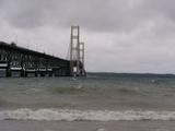
After a bit of driving up I-75 [2
Pictures], the first thing to see was the Mackinac Bridge, which
carries I-75 from the Lower Peninsula to the Upper Peninsula, with
Lake Michigan to the west and Lake Huron to the east [11 Pictures*]. From there, it was the
rest of I-75 [Picture] up to its northern
terminus [4 Pictures] in Sault
Ste. Marie. We stopped for a quick, rainy look at the Soo Locks and
for some lunch [4 Pictures]. We backtracked
a bit to get on M-28 west [2 Pictures]
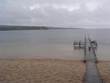
toward the Pictured Rocks National Lakeshore. We
got off M-28 to take
some county roads toward the lake [2
Pictures]. We stopped to see the Munising Falls [9 Pictures*] and drove out to a sandy beach
[4 Pictures*] and Sand Point [5 Pictures*]. We got some elevated
views of the same areas from an overlook just east of Munising [4 Pictures*]. Then we continued to
Marquette before turning north toward Houghton and the Keweenaw
Peninsula [5 Pictures]. We grabbed
some dinner in Houghton and drove [Picture] to Copper Harbor to see the
northern terminus of US 41 [5 Pictures*]
and to check out the excellent scenery up there [13 Pictures*]. In addition to the signs
at the real end of US 41, they also have a sign marking the distance
to Miami [Picture*]. We made our way back
along the lakeshore on M-26, which had excellent views, made even
better by the setting sun breaking through the clouds. This side trip
made for a late ride down to Ironwood, though it still wasn't
completely dark even by 11 PM. [Just Sign
Pictures].
Day 5 Travel Log
Saturday, July 12, 2003
|
 |
 |
We left Ironwood fairly early and got into Wisconsin [Picture] within minutes. Our ride
across northern Wisconsin was pretty uneventful, with the only
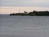
reasonably interesting pictures coming near Ashland [4 Pictures] and Superior [2 Pictures]. When we got to Duluth,
Minnesota [3 Pictures], we drove around a
bit and found a spot (Leif Erickson Park) to walk down to the water at
the western end of Lake Superior [5
Pictures]. From there, it was westward through Grand Rapids for
lunch, getting into the Mississippi Headwaters area [Picture]. We stopped in Bemidji to see
Paul Bunyan and Babe the Blue Ox [4
Pictures], then cut a bit south to Lake Itasca State Park [3 Pictures] to see the official headwaters
of the Mississippi River [6
Pictures*]. After looking around there a bit, we drove over to
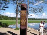
Grand Forks, North Dakota and checked out the new flood memorial [2 Pictures]. We decided at that point
that a trip out US 2 toward Minot would make for too long a day on
Sunday, so we drove south to Fargo to get a room and to grab dinner at
Famous Dave's. [Just Sign Pictures].
Day 6 Travel Log
Sunday, July 13, 2003
|
 |
 |
We started in Fargo with a forecast for a chance of severe storms to
our west (where we were headed). We made our way across the flatness
of eastern North Dakota [3 Pictures], then
made a lunch stop in Bismarck [Picture], drove across more I-94 [2 Pictures], then and a gas stop in Dickinson.
The storms popped up, but not until we were beyond Dickinson, so we
stayed dry and hot. It was over 100 in Dickinson - I saw an official
reading of 103 and my car had a reading as high as 106 [Picture]. We got to the day's big stop,
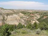
Theodore Roosevelt National Park, by early
afternoon. We stopped first at the Painted Canyon overlook off of I-94 [8 Pictures*], and then went into the main
part of the park [Picture] and did the loop
road. The ride is spectacular, but the heat was pretty intense,
hovering in the upper 90's and low 100's under a mostly clear sky.
Our first picture stop was at a prairie dog town just onto the Scenic
Loop Drive, where we also saw a herd of bison [8 Pictures*]. Next, the Scoria Point
overlook [5 Pictures*], Badlands Overlook
[6 Pictures*], and another turnout [2 Pictures]. We hiked the Coal Vein Trail
through an area that was the site of a 26-year underground coal fire
[14 Pictures*], then made more picture
stops [3 Pictures] including one at Wind
Canyon [11 Pictures*]. After the
park, it was on into Montana [4
Pictures] and to our destination for the night in Billings. Just
at dusk, we hit a dry but gusty thunderstorm that made the driving a
bit more challenging. [Just Sign
Pictures].
Day 7 Travel Log
Monday, July 14, 2003
|
 |
 |
We left Billings in the morning with the bugs from the ride so far
caked onto the front of the car [Picture]
and headed out US 212 [Picture] toward
the Northeast entrance of Yellowstone National
Park. Once beyond Red
Lodge [2 Pictures], this is a
spectacular drive. It starts by going up a valley, which is nice
enough [4 Pictures], but then
the climbing really starts [6
Pictures]. At 9190 feet, we stopped at a parking lot and trail to
scenic views called the Rock Creek Vista Point [9 Pictures*]. Around 10,000 feet, we
reached some snow on the side of the road [3
Pictures]. We stopped for a few pictures at the Wyoming-Montana
border [4 Pictures]. As we climbed
beyond 10,000 feet, we stopped to take some pictures on the side of
the roads [3 Pictures*] and again at a
turnout at what seemed to be the top of a ski lift [5 Pictures*]. We also stopped at the West
Summit on US 212 [9 Pictures*].
Along the way down the other side, we stopped to look at a small lake
[5 Pictures*] and at a couple of other
spots [6 Pictures]. There was a
nice little waterfall where the old road bridge provided some good
views [5 Pictures]. It was just a bit
further [4 Pictures] before we got back
into Montana. We stopped for lunch in Cooke City [2 Pictures], passed through Silver Gate,
then entered Yellowstone National Park at the
Northeast Entrance [3 Pictures*]. We
stopped to take a few pictures along (I think) the Lamar River [2 Pictures], but our first major stop was at
Tower Falls [Picture]. The trail to the
base of the falls was closed because of a trail washout, so we only
got to see it from the top. We stopped at a viewpoint near Tower
Junction for some views of the canyon [11
Pictures*], then it was on to the Petrified Tree [2 Pictures*] and the Forces of the North
Self-Guided Trail [2 Pictures]. We hiked
the half mile to see the Wraith Falls [3
Pictures] and stopped at the pullout for the Undine Falls [3 Pictures]. We drove through Mammoth then
up to Gardiner to see the original entrance arch [2 Pictures*], then returned to Mammoth [4 Pictures] to check out the hot springs.
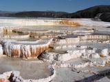
Our first stop was to walk around the Lower Terrace area [18 Pictures*]. We also drove the
Upper Terrace Drive to check out some more springs up there. At the
first major parking lot, we saw a lot of the New Blue Spring, probably
the nicest one of the day [7 Pictures*].
We just drove around for the rest of the loop [7 Pictures]. On the way down the
west side of the main upper loop, we stopped to look for moose at one
turnout (didn't see any) [Picture], to
look at some elk [2 Pictures], and to see
Roaring Mountain [3 Pictures]. Our last
stop of the day was the Norris Geyser Basin [20 Pictures*] before we left the park for
the night in West Yellowstone.
Day 8 Travel Log
Tuesday, July 15, 2003
|
 |
 |
This was the full day in Yellowstone. We started by picking up some
lunch to take into the park and by washing a lot of bugs off the car
in West Yellowstone [Picture].
We ran across an elk buck on the way in [2
Pictures] near Madison. We cut across the road from Norris to
Canyon, and took the Virginia Cascade road and saw, yes, the Virginia
Cascade [3 Pictures]. Our first major
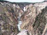
stop was at the Canyon area. We made stops at Inspiration Point [7 Pictures*], the Grand View [4 Pictures], then Lookout Point [2 Pictures]. At Lookout Point, we also
took the more difficult trail to Red Rock Point. The trail isn't so
long, just 3/8 mile, it's just that 500 foot elevation change. The
view was nice, though [5 Pictures*].
The trail to the brink of the Lower Falls was closed for maintenance,
so we had to skip that, but we took the (much shorter) trail to the
brink of the Upper Falls instead [5
Pictures]. From there, it was across the river to get the classic
view of the Lower Falls from Artist Point [4
Pictures*]. We headed south toward the lake, making a stop at
Sulphur Cauldron [2 Pictures] before
lunch along the Yellowstone River. We did the whole walking loop at
the Mud Volcano area, including the Dragon's Mouth Spring [3 Pictures*], the Mud Volcano [Picture], Sour Lake [3
Pictures], Black Dragon's Caldron [3
Pictures], Churning Caldron [3
Pictures], Sizzling Basin [3
Pictures], Mud Geyser [2
Pictures], and Mud Caldron [2
Pictures] (yes, lots of mud around there). On next to the Lake
Yellowstone area, with stops at Lake Village [2 Pictures] and a road along the shore
[4 Pictures]. Next stop was the West
Thumb Geyser Basin [Picture], where
we again did the whole walk, passing the Thumb Paint Pots [3 Pictures], Bluebell and Seismograph
Pools [7 Pictures*], Lakeside Spring [3 Pictures], Fishing Cone [Picture], Big Cone [Picture], Black Pool [5 Pictures*], Abyss Pool [5 Pictures*], Blue Funnel Spring [2 Pictures*], Percolating Spring [Picture], Ledge Spring [Picture], Surging Spring [2 Pictures], and more [3 Pictures]. By then it was late afternoon,
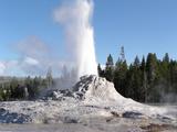
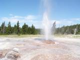
and we continued on to Old Faithful. It was erupting when we arrived
[6 Pictures], so we watched the
eruption then set out for a long walk around the Upper Geyser Basin [4 Pictures]. It was a very fruitful walk,
with several geysers erupting just in time for us to see them.
Outstanding. We got to see nearly simultaneous eruptions of Anemone
Geyser [5 Pictures*] and Plume Geyser [5 Pictures]. We walked past Beehive Geyser
[Picture], Liberty Pool [2 Pictures], and Beauty Pool [2 Pictures], then crossed the Firehole
River [4 Pictures] in time to see some
nice action from Grotto Geyser [10
Pictures*]. We walked out to the end of the improved path to see
the famous Morning Glory Pool [4
Pictures*]. We decided to take the side loop to see Daisy Geyser
and we were very nicely rewarded with an excellent eruption [8 Pictures*]. Our lucky timing continued
when we arrived at Castle Geyser just as it was starting to erupt [11 Pictures*]. After the walk, we checked
out the Old Faithful Inn [4 Pictures] for a
few minutes, saw another Old Faithful eruption [2 Pictures*], grabbed a quick dinner,
then made our way back to West Yellowstone.
Day 9 Travel Log
Wednesday, July 16, 2003
|
 |
 |
We started out with a 2-mile detour to the Idaho border [3 Pictures], then headed into the park. We
got to see a few bald eagles along on the road to Madison [3 Pictures*]. Our first destination was a
side trip along the Firehole Canyon Drive. This mainly brought us to
the Firehole Falls [Picture] and
provided some views of the Firehole Canyon. Next we stopped at the
Fountain Paint Pot area and took the walk around the basin there. We
passed a Bacteria Mat [Picture] and
Silex Spring [Picture] before getting to
the Fountain Paint Pots themselves [3
Pictures*]. The loop continues with a walk past some apparently
unnamed fumaroles [Picture] then off
to a cluster of geysers including the erupting Clepsydra Geyser [6 Pictures]. We continued with a drive
along Firehole Lake Drive, where we got to see Firehole Spring [4 Pictures*], where the bubbles
coming up from the spring actually do look kind of like white fire
inside the spring, and Surprise Pool [2
Pictures], a very hot pool where they say people used to toss in
sand to see the water boil. Then we got lucky again and caught part
of an eruption of the Great Fountain Geyser. We missed the beginning
and most spectacular part of the eruption, but it was still pretty
impressive and was sending out a lot of water [8 Pictures*]. We didn't see an
eruption of the White Dome Geyser [2
Pictures], but got lucky yet again and saw an eruption of the Pink
Cone Geyser [10 Pictures*]. This one
is right by the road, so we were able to get up closer to it than to
most. It actually sprayed my car a bit on our way out. We didn't get
out of the car for Steady Geyser [3
Pictures]. After this very successful visit to Firehole Lake
Drive, it was on to the Midway Geyser Basin to see the algae and
bacteria in the streams that carry water from the springs into the
Firehole River [2 Pictures*], walked
around the Excelsior Geyser Crater [6
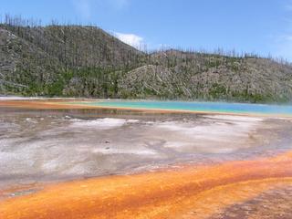
Pictures*], and got a good look at the spectacular Grand Prismatic
Spring [7 Pictures*]. This is the largest
and one of the most colorful springs in Yellowstone. We finsihed up
Midway by heading back around by Turquoise Pool [2 Pictures]. We decided we had time for
one more basin, and decided to stop at Black Sand [2 Pictures], where we saw a bit of an
eruption of the Cliff Geyser [5 Pictures],
and walked by the Rainbow Pool [2
Pictures] and Sunset Lake [3
Pictures] as well. From there, we needed lunch and got it at
Grant Village. It would have been nice to get to see some more of the
exhibits and the movie about the 1988 fires, but we wanted to make
sure we left time for the Grand Tetons. So we left Yellowstone by the
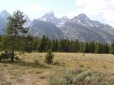
South Entrance and headed first onto the Rockefeller Parkway [Picture] and then into Grand Teton National Park [Picture]. We stopped for
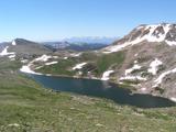
some pictures near the north end of Jackson Lake [4 Pictures*] then stopped at the Visitors
Center in Colter Bay [4 Pictures]. We
took the Teton Park Road along Jackson Lake and then Jenny Lake,
stopping for pictures at the Mount Moran turnout [6 Pictures*], the Cathedral Group turnout
[3 Pictures], the Jenny Lake turnout
[7 Pictures*] and the Teton Glacier
turnout [5 Pictures]. At the end
of the loop, we turned back north on the main road, stopping for
overlooks of the glaciers [4
Pictures] and of the Snake River [4
Pictures], and taking a side trip down a dirt road to the shore of
the Snake River [4 Pictures]. From
there, it was on to Dubois for the night, passing over Togwatee pass
on US 26 and US 287 [4 Pictures]. While
waiting for our laundry, we took a ride up a hill in Dubois to get
some great views of the area [7
Pictures*].
Day 10 Travel Log
Thursday, July 17, 2003
|
 |
 |
Before leaving Dubois [2 Pictures], we
made a quick stop at the Bighorn Sheep Interpretive Center, where we
learned that we weren't going to be seeing any of them, since they're
all up in the high mountains for the summer. We headed east out of
there, passing through Riverton, seeing some nice scenery along US 20
[3 Pictures] and through Thermopolis [Picture] to our lunch stop in Worland
[Picture]. We took US 16 across the
Bighorns [9 Pictures], which was nice but
not nearly as good as the US 14/Alt US 14 routes further north. We
also hit some construction delays as we descended into Buffalo. We
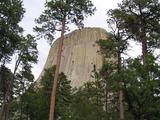
decided we had time for a quick visit to Devils Tower [5 Pictures*], then crossed over into South
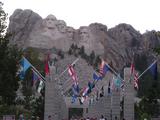
Dakota. After checking in in Rapid City, we drove down to Mount
Rushmore for a dusky view of the Big Stone President Heads [2 Pictures]. The crowd was building for
the lighting ceremony after dark, so we decided to head back to Rapid
City before it got too late. [Just Sign
Pictures].
Day 11 Travel Log
Friday, July 18, 2003
|
 |
 |
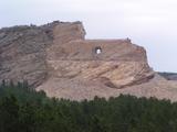
After driving down through Hill City [Picture], our first stop in the morning
was the Crazy Horse Monument [8
Pictures*] near Custer. I had no idea there was so much progress
on the actual carving in recent years, and I had even less of an idea
that the visitors center was as big and nice as it is. Definitely
worth a visit. From there, we passed through Custer and on to
Wind Cave National Park
[Picture]. We
bought tickets for the noon Natural Entrance cave tour [Picture]. This was really nice,
as we got to walk down from the surface to 200 feet down over about a
mile. The cave was very interesting and very different from your
typical caves. The main feature is the "boxwork" which consists of
delicate formations formed when cracks in the limestone filled in with
harder material were left behind as the limestone dissolved. Pretty
amazing [First 18 Pictures*][Next 18 Pictures*][Last 18 Pictures*]. At the end of the
tour, we got an elevator ride back up. Next up, we did the wildlife
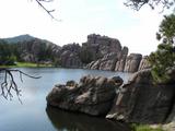
loop tour in Custer State Park [6 Pictures*]
and took the Needles Highway [25
Pictures*] through Sylvan Lake [6
Pictures*] back up toward the Mt. Rushmore area. Passing through
Keystone again, we grabbed a picture of what seems to be a recent fire
[Picture]. Back in Rapid City, we went
for dinner at Carini's, the same Italian restaurant Amitha, Nathan,
and I went to in 1999, then to the Armadillo for ice cream, also the
same place we went in 1999. [Just Sign
Pictures].
Day 12 Travel Log
Saturday, July 19, 2003
|
 |
 |
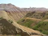
We left Rapid City in the morning and headed out Highway 44 toward
Interior to take a different way into the Badlands [7 Pictures]. We did the Badlands Loop
westbound [14 Pictures*], grabbed lunch
and ice water at Wall Drug and then headed out I-90 East. Originally,
we planned to cut down into Nebraska and across Iowa on this day, but
a last minute change is leading us to Kansas City and St. Louis, and
KC is the day's destination, to visit some of Cathy's relatives. The
ride out I-90 [7 Pictures] and down I-29 [4 Pictures] was pretty uneventful but a lot of
driving. [Just Sign Pictures].
Day 13 Travel Log
Sunday, July 20, 2003
|
 |
 |
We got a very good breakfast in Leawood, Kansas, then headed east for
St. Louis by late morning. The ride across I-70 [4 Pictures] was fine, though construction near
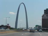
St. Louis slowed us a bit. After getting to St. Louis [Picture] and Charles' apartment, we went out
to see where he works at Bitrode in Fenton [4 Pictures], stopped to see his new car [3 Pictures] at a dealer south of St. Louis,
saw the location where his van died [Picture], then came back to see his van
[4 Pictures] and walked to get dinner at
Dressel's back near Forest Park before going back to his apartment [9 Pictures] for the night. [Just Sign Pictures].
Day 14 Travel Log
Monday, July 21, 2003
|
 |
 |
Charles had to head out to work in the morning, so we got a pretty
early start. We grabbed one picture of his last ride to work in the
van [Picture] before getting onto I-64.
There were some nasty storms in the forecast along our intended route,
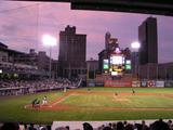
so we cut north up I-55, I-72, and I-57 toward Chicago. We took US
30, the old Lincoln Highway route [6
Pictures] into Indiana then north on US 41 to get back on the
interstates. We managed to stay dry and got to the Toledo area just
in time to stop for a baseball game, the Pawtucket Red Sox against the
Toledo Mud Hens. [21 Pictures*]. The
game was delayed a half hour by a dark cloud, but it never actually
rained. The Red Sox won, 8-4. After the game, we drove a little
further down the road to spend the night in North Ridgeville. [Just Sign Pictures].
Day 15 Travel Log
We started out from North Ridgeville by mid-morning, making a lunch
stop in Erie, then taking the ride across I-86, NY 17, I-88 and NY 30
to get back to Amsterdam. After a Russo's dinner, Cathy headed off to
West Springfield and I returned to Williamstown. [Just Sign Pictures].
Day 16 Travel Log
Some Stats
- In a little under 16 days, we covered 6444.8 miles.
- The easternmost point was Williamstown, the westernmost point was
the Idaho border near West Yellowstone, the northernmost point was
Grand Forks, North Dakota, and the southernmost point was Fenton,
Missouri.
- For me, the trip covered 18 states: Massachusetts, New York,
Pennsylvania, Ohio, Michigan, Wisconsin, Minnesota, North Dakota,
Montana, Wyoming, Idaho, South Dakota, Iowa, Missouri, Kansas,
Illinois, Indiana and Vermont, plus Ontario, Canada. We saw Nebraska
from I-29, but did not go across the Missouri River to add it in.
- We burned 223.75 gallons of gas for 28.8 MPG.
- 1173 pictures made the cut and got onto these pages.
And as usual, the pictures you see here don't come close to showing
what this stuff really looks like. You just have to go.
E-mail domain: teresco.org, username: terescoj -
Thu Jul 24 15:54:25 EDT 2003
Copyright notice: All images are copyright © James D. Teresco unless otherwise specified. Unauthorized use is prohibited.